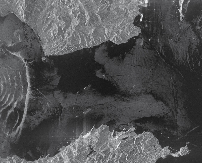
The invisible underwater waves caused by the encounter between the saltier, denser waters of the Mediterranean Sea and the surface waters of the Atlantic become visible from space. That's the spectacular image chosen by e-Geos, a company providing Earth Observation services and established by Telespazio (80%) and the Italian Space Agency (20%), to celebrate World Oceans Day today.
The strait between Africa and Europe is the gateway that joins the Mediterranean Sea with the Atlantic Ocean, and in this extraordinary image taken by one of Asi's Italian Cosmo-SkyMed satellites, we catch a glimpse of its complexity. Due to the different salt concentration of the two seas, two different and opposite currents are formed: a surface one that carries water from the ocean (left) to the sea and a deeper one, with the reverse path, that carries the saltier and denser water of the Mediterranean Sea to the Atlantic.
In the radar image, the territories of Spain to the north and Morocco to the south are clearly visible, as are the waves within the currents. The semi-circular ripples of water to the east of the strait, not easily visible on the surface because they do not generate large waves, are instead visible with radar, which is sensitive to changes in the 'roughness' of the sea. Sixty kilometres long and just 14 kilometres wide at its narrowest point, the Strait of Gibraltar is one of the busiest passages in the world, crossed by at least one ship every five minutes, and it is also a vital trade gateway for the survival of the Mediterranean ecosystem through which large numbers of living creatures also migrate.


Caricamento commenti
Commenta la notizia